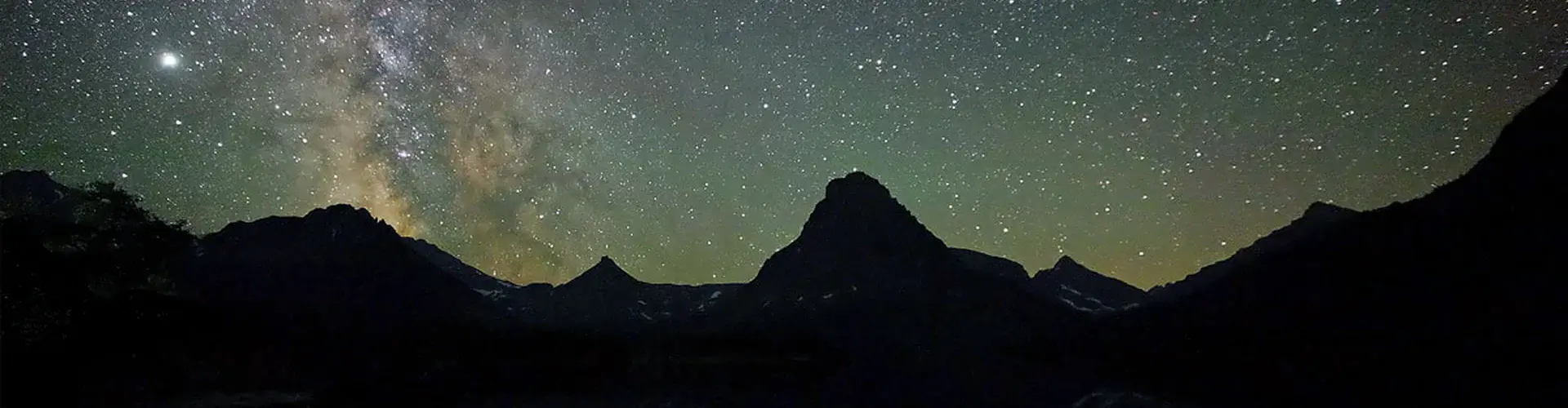
First observations of continuum emission in dayside aurora Annales Geophysicae DOI 10.5194/angeo-43-349-2025 9 July 2025 We studied the first broad band emissions, called continuum, in the dayside aurora. They are similar to Strong Thermal Emission Velocity Enhancement (STEVE) with white-, pale-pink-, or mauve-coloured light. But unlike STEVE, they follow the dayside aurora forming rays and other dynamic shapes. We used ground optical and radar observations and found evidence of heating and upwelling of both plasma and neutral air. This study provides new information on conditions for continuum emission, but its understanding will require further work. Read more
Is drought protection possible without compromising flood protection? Estimating the potential dual-use benefit of small flood reservoirs in southern Germany Hydrology and Earth System Sciences DOI 10.5194/hess-29-2785-2025 7 July 2025 In this paper, we use models to demonstrate that even small flood reservoirs – which capture water to avoid floods downstream – can be repurposed to release water in drier conditions without affecting their ability to protect against floods. By capturing water and releasing it once levels are low, we show that reservoirs can greatly increase the water available in drought. Having more water available to the reservoir, however, is not necessarily better for drought protection. Read more
Qualitative risk assessment of sensitive infrastructures at the local level: flooding and heavy rainfall Natural Hazards and Earth System Sciences DOI 10.5194/nhess-25-2097-2025 4 July 2025 In post-disaster reconstruction, emphasis should be placed on critical and sensitive infrastructures. In Germany, as in other countries, sensitive infrastructures have not yet been focused on; therefore, we developed a method for determining the risk that sensitive infrastructures are facing in the context of riverine and pluvial flooding. The easy-to-use assessment framework can be applied to various sensitive infrastructures, e.g., to qualify and accelerate decisions in the reconstruction process. Read more
Phylogeochemistry: exploring evolutionary constraints on belemnite rostrum element composition Biogeosciences DOI 10.5194/bg-22-3073-2025 2 July 2025 Belemnite rostrum geochemistry is used as a proxy in palaeoceanography. Evolutionary patterns in element ratios (Mg/Ca, Sr/Ca, Mn/Ca, and Fe/Ca) from belemnite rostra based on a literature dataset are assessed. These proxy data reflect a complex interplay between evolutionary, ontogenetic, environmental, kinetic, and diagenetic effects. We coin the new term “phylogeochemistry” for this interdisciplinary research field. Read more
The satellite chlorophyll signature of Lagrangian eddy trapping varies regionally and seasonally within a subtropical gyre Ocean Science DOI 10.5194/os-21-1141-2025 30 June 2025 Eddies are rotating ocean vortices up to hundreds of kilometers in diameter that stimulate phytoplankton blooms. We used satellite data and simulations of currents to examine the effect of eddy trapping strength on phytoplankton concentration in the open North Pacific Ocean. Coherent eddies trap phytoplankton, while “leaky” ones have lower concentrations because they mix with surrounding waters. However, contrary to previous theory, eddy-trapped blooms are more prominent in southern latitudes. Read more
Long-term prediction of the Gulf Stream meander using OceanNet: a principled neural-operator-based digital twin Ocean Science DOI 10.5194/os-21-1065-2025 20 June 2025 The Gulf Stream is a prominent oceanic feature in the northwestern Atlantic Ocean that influences weather patterns in the Northern Hemisphere and is notoriously difficult to predict. We present a machine learning model, OceanNet, to predict the position of the Gulf Stream months in advance. OceanNet is able to perform a 120 d prediction 4 000 000 times faster than traditional methods of ocean modeling with great accuracy. Read more
Using 3D observations with high spatio-temporal resolution to calibrate and evaluate a process-focused cellular automaton model of soil erosion by water SOIL DOI 10.5194/soil-11-413-2025 16 June 2025 This study develops a new method to improve the calibration and evaluation of models that predict soil erosion by water. By using advanced imaging techniques, we can capture detailed changes in the soil surface over time. This helps improve models that forecast erosion, especially as climate change creates new and unpredictable conditions. Our findings highlight the need for more precise tools to better model erosion of our land and environment in the future. Read more
The potential of observing atmospheric rivers with Global Navigation Satellite System (GNSS) radio occultation Atmospheric Measurement Techniques DOI 10.5194/amt-18-2481-2025 12 June 2025 The study investigates using Global Navigation Satellite System Radio Occultation (GNSS-RO) to analyze the vertical structure of humidity in atmospheric rivers (ARs). Specific humidity and integrated water vapor from the COSMIC Data Analysis and Archive Center (CDAAC) and the Wegener Center (WEGC) are compared with the Special Sensor Microwave Imager/Sounder (SSMIS), showing that GNSS-RO adds vertically resolved data. Despite a slight low bias, combining GNSS-RO and SSMIS improves AR analysis. Read more
Implications of reduced-complexity aerosol thermodynamics on organic aerosol mass concentration and composition over North America Atmospheric Chemistry and Physics DOI 10.5194/acp-25-5773-2025 12 June 2025 We implemented the BAT-VBS (Binary Activity Thermodynamics volatility basis set) aerosol thermodynamics model in the GEOS-Chem chemical transport model to efficiently account for organic aerosol water uptake, nonideal mixing, and impacts on the gas–particle partitioning of semi-volatile organics. Compared to GEOS-Chem’s complex (dry) scheme, we show that the BAT-VBS model can predict substantial enhancements in organic aerosol mass concentration at moderate-to-high relative humidity. Read more
GC Insights: Consistency in pyrocartography starts with color Geoscience Communication DOI 10.5194/gc-8-167-2025 11 June 2025 Fire progression maps (FPMs) provide information regarding wildland fire spread (progress) through time to broad audiences. However, information regarding the best use of color to denote fire progression via maps is limited. This can potentially limit a map’s ability to effectively communicate information by creating inconsistent messaging and accessibility challenges. Here, I provide color map recommendations to open a discussion towards consistent and accessible fire progression mapping. Read more