
New model predicts landslides along wildfire burn scars: an early warning system for high-risk areas
27 July 2022
MUNICH – A wildfire followed by an intense rainstorm is often a recipe for disaster. Without vegetation to cushion rainfall, water runoff can turn into a fast-moving, highly destructive landslide, called a “debris flow,” which often has the power to wipe out cars, homes and highways — sometimes resulting in casualties.
Now, Northwestern University researchers have expanded a physics-based numerical model to investigate and predict areas susceptible to debris flows. This model could eventually be used in an early warning system for people living in high-risk areas, enabling them to evacuate before it’s too late. Information from model simulations also could be used to design new infrastructure — such as diversion bars that deflect fast-moving water away from homes and roads — for high hazard zones.
The research was published on July 27 in the European Geosciences Union journal Natural Hazards and Earth System Sciences.
“People want to know about their immediate and future risk,” said Northwestern’s Daniel Horton, the study’s senior author. “Although it’s not yet to operational standards, this modelling framework could one day be instrumental in forecasting where debris flows are likely to occur and deciding who needs to be evacuated.”
Horton is an assistant professor of Earth and planetary sciences in Northwestern’s Weinberg College of Arts and Sciences, where he also leads the Climate Change Research Group. Chuxuan Li, a PhD candidate in Horton’s laboratory, is the paper’s first author.
Increasing debris flow ‘ingredients’
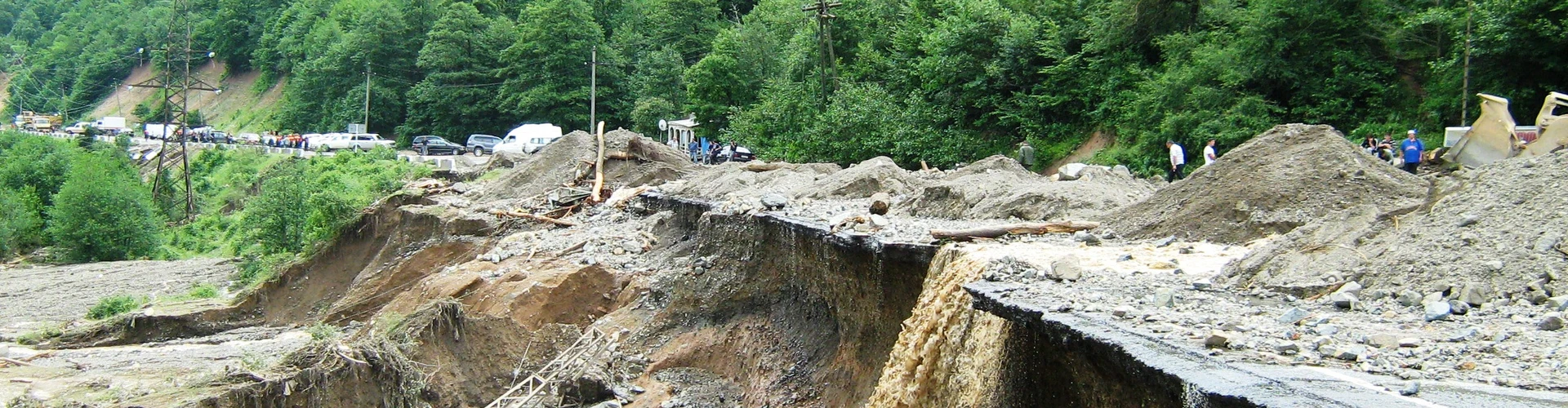
As climate change increases the likelihood of wildfires and heavy rains, debris flows also might become more common. Just last year, a debris flow tore out a 150-foot section of roadway along Highway 1 near Big Sur, California. The picturesque two-lane highway was closed for three months, cutting off tourism to the region.
The disaster resulted from a one-two punch: A wildfire that burned from August through December 2020, followed by an atmospheric river — a long, thin string of concentrated moisture in the sky — that dumped nearly a foot of rain the following January.
Following intense rainfall, areas with wildfire burn scars are more susceptible to flash flooding. In a typical situation, vegetation interacts with rain, which then soaks into the ground. But if an area is burned, vegetation is gone, so it can no longer intercept the sudden influx of moisture. Even worse: In some regions, waxes from burned vegetation melts, enters the soil, and then solidifies. These waxes create a barrier for rain, blocking it from penetrating the soil. Instead, rain runs over the top of the soil, picking up rocks, mud, trees and even cars to become a debris flow.
“Because of human-caused climate change, the ingredients that lead to debris flows are certainly becoming more common,” Horton said. “Due to intensified precipitation, drought and wildfires, debris flow conditions are particularly prevalent in California.”
Pinpointing susceptible areas
To develop the new model, Horton’s team adapted the National Oceanic Atmospheric Administration’s National Water Model, which is used to simulate streamflow and water resources across the continental United States.
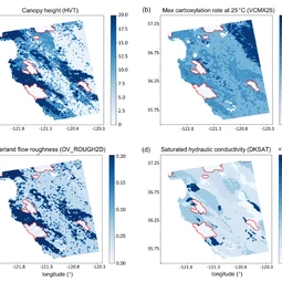
“The National Water Model is a community, open-source model, so researchers use it to probe all sorts of pertinent water resource and hazard questions,” Horton said. “But one thing the model didn’t explicitly output was overland flow — water that runs across the land after rainfall. We modified the model to look at how extreme precipitation moves over land surfaces, which allows us to investigate how susceptible certain land surfaces, and in particular burn scars, are to debris flow.”
By adjusting vegetation type (dense vs. barren, for example) and soil properties, the researchers were able to replicate how water moves over wildfire burn scars. The team then validated the model-simulated hydrological conditions using soil moisture and streamflow observations.
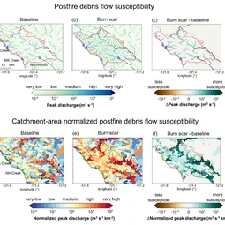
The resulting simulation found that burned areas cause water to flow much faster and in greater volumes compared to unburned land. When simulating the debris flow that took a bite out of Highway 1, for example, the researchers found overland flow volume increased eight-fold and peak flow tripled compared to land without burn scar characteristics.
“An advantage of our model is that it uses precipitation as it would fall in the real world,” Horton said. “We’re simulating spatially complex and time-evolving precipitation and how that precipitation interacts with the land surface.”
“Our physics-based hydrological model opens up new possibilities for better understanding of burn scar hydrology and debris flow susceptibility,” Li said. “Given the increasing likelihood of debris flow conditions due to climate change, developing models to better understand past events and predict future events is essential.”
The study, “Augmentation of WRF-Hydro to simulate overland flow- and streamflow-generated debris flow susceptibility in burn scars,” was supported by the National Science Foundation (award number 1848683).
More information
The European Geosciences Union (EGU) is Europe’s premier geosciences union, dedicated to the pursuit of excellence in the Earth, planetary, and space sciences for the benefit of humanity, worldwide. It is a non-profit interdisciplinary learned association of scientists founded in 2002 with headquarters in Munich, Germany. The EGU publishes a number of diverse scientific journals that use an innovative open access format and organises topical meetings plus education and outreach activities. Its annual General Assembly is the largest and most prominent European geosciences event, attracting more than 14,000 scientists from all over the world. The meeting’s sessions cover a wide range of topics, including volcanology, planetary exploration, the Earth’s internal structure and atmosphere, climate, energy, and resources. For more information, follow the EGU on Twitter and Facebook.
If you wish to receive our press releases via email, please use the Press Release Subscription Form at https://www.egu.eu/news/subscribe/. Subscribed journalists and other members of the media receive EGU press releases under embargo (if applicable) 24 hours in advance of public dissemination.
Contact
Gillian D’Souza
Media and Communications Officer
European Geosciences Union
Munich, Germany
Emailmedia@egu.eu