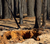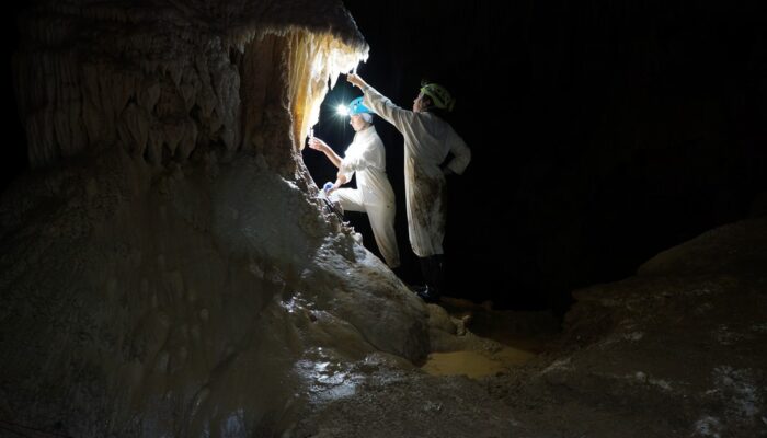
The photo shown here shows typical sampling work underground. You can see Ola Kwiecien and Cinthya Nava Fernandez, researchers at Ruhr University Bochum in Germany, collecting dripwater in New Zealand’s Waipuna Cave as part of a four-year EU-funded monitoring programme. Our research aims at developing innovative geochemical indicators that we can use to quantify changes in the hydrological system or biosphere above the cave that result from variations in weather patterns and climate.
Caves are fantastic natural archives and laboratories. One can imagine caves like libraries of natural history: they host carbonate formations (such as stalagmites, stalactites, flowstones etc., collectively known as speleothems) which, like books, can be read by geochemists to learn about past climatic and environmental conditions. Importantly, these ‘stone books’ must, on the one hand, be protected from destruction by weathering, and on the other, must be written in a language that we can decipher. The secluded cave environment greatly helps protect speleothems from erosion and weathering, while monitoring the cave environment and hydrology allows us to learn the alphabet which nature uses to write natural history into the speleothems. Only then can we reconstruct, and ideally quantify, past environmental conditions.
Of special importance for our work in New Zealand is the El Nino-Southern Oscillation and the southern Westerlies. These two atmospheric subsystems strongly influence weather and climate in New Zealand. Southward or northward shifts of the Westerlies influence New Zealand crop yields and tourism, as well as the fishing economy, among others. El Nino and La Nina have equally strong impacts on weather patterns in New Zealand (and, in fact globally).
Despite many years of research, the mechanisms that cause changes to the ENSO and the Westerlies, and their interaction, still remain poorly understood. This lack of knowledge limits scientists’ efforts to estimate the magnitude and direction of changes that might result from ongoing global warming.
Our team of German, British and New Zealand geochemists, mathematicians, palaeoclimatologists and modellers set out to develop innovative tools and methods that would allow researchers to quantify, for example, changes in rainfall or seasonality, with the ultimate goal that these should be applicable globally. The manual sampling depicted in the photo might soon be replaced by an automatic sampler, which would greatly reduce the costs for regular fieldwork. Especially in remote settings such robots would be of great benefit for our research.
Our team also developed new proxies, such as a lignin-based (biomarker) proxy that allows us to reconstruct changes in vegetation above the cave. We also explored how transition metals behave in the hydrological system of caves, and the factors that control how these metals are transported and incorporated into speleothems. These research activities will hopefully give us powerful and very sensitive tools to quantify changes of environmental parameters, including rainfall, temperature, soil and vegetation and the underlying forcings, like ENSO. Until we have our tool kit properly calibrated, we continue our visits to Waipuna and other caves in New Zealand and Germany.
Our QUEST project has received funding from the European Union’s Horizon 2020 Research and Innovation programme and the Royal Society of New Zealand. Find more at http://quest.pik-potsdam.de/
By Sebastian Breitenbach, Ruhr University Bochum (Germany), and Adam Hartland, University of Waikato (New Zealand)
Imaggeo is the EGU’s online open access geosciences image repository. All geoscientists (and others) can submit their photographs and videos to this repository and, since it is open access, these images can be used for free by scientists for their presentations or publications, by educators and the general public, and some images can even be used freely for commercial purposes. Photographers also retain full rights of use, as Imaggeo images are licensed and distributed by the EGU under a Creative Commons licence. Submit your photos at http://imaggeo.egu.eu/upload/.