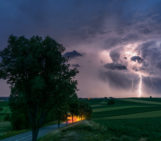
In the Sierra de Aconquija, a mountain range in the southern Central Andes of Argentina, strong storms often come and go at a moment’s notice, but they can have a long-lasting impact on the Earth’s surface.
The thunderstorm cell featured in this photo formed in less than half an hour, giving all those nearby only a few minutes to take cover. Mitch D’Arcy, a geomorphologist and postdoctoral researcher at the University of Potsdam and the GFZ German Research Centre for Geosciences, had the opportunity to witness this storm (and snap this picture!) while carrying out field work in the area.
“It was a spectacular experience, pouring heavy rain onto a very localised part of the mountain range, but it was also a hazard because the storm was quickly moving towards us with a lot of lightning. Without any trees around, we were likely targets for lightning strikes!” said D’Arcy. Luckily, he and his colleagues were able to find shelter in their truck while the huge downpour passed over them.
These kinds of thunderstorms are short-lived, but have intense precipitation rates. In this case, the temperature dropped by 14 degrees Celsius, and the storm was accompanied by heavy hail and lightning. And while these natural hazards are transient, they can have a long-term impact on the region’s landscape. Severe storms are capable of triggering landslides and floods and can relocate large amounts of sediment and debris in a short period of time.
D’Arcy is part of an international research programme called StRATEGy (Surface processes, Tectonics and Georesources: The Andean foreland basin of Argentina), which looks into how past and present climate change makes a mark on the terrain of the Argentine Andes, among other topics.
This research is essential for understanding and predicting how human-caused climate change will alter weather patterns and impact surface processes (such as how quickly sediments are eroded and transported across landscapes), according to D’Arcy. Having a better understanding of these surface processes and their sensitivity to the climate could help scientists better inform the public about how to prepare for natural hazards, such as flooding, erosion and landslides.
D’Arcy notes that it’s also important to assess how climate and weather trends will impact the sedimentary record, since it is one of the only physical records that scientists can use to examine how the Earth’s surface has change through time.
“North-western Argentina is a fascinating place to study how climate change affects surface processes, because it has experienced pronounced and abrupt changes in hydroclimate through time,” said D’Arcy. Their research has found that even subtle changes in the region’s climate have produced large changes to the surface environment, impacting how rivers take shape and how sediments move.
For example, while the Sierra de Aconquija is a semi-arid environment today, more than 12,000 years ago it used to be much wetter as a result of global climate changes. In fact, back then the mountain range was covered in glaciers and many of the basins were filled with lakes.
“It’s really important that we understand how different landscapes function and how they react to changes in climate. When we look at places like the southern Central Andes in Argentina, we find that the landscape records interesting signatures of ancient climate changes in Earth’s past. However, one of the big questions we still don’t have a good answer to, is how important are these very intense but rare storms for shaping landscapes and creating the sedimentary record from the geological past,” said D’Arcy.
By Olivia Trani, EGU Communications Officer
Imaggeo is the EGU’s online open access geosciences image repository. All geoscientists (and others) can submit their photographs and videos to this repository and, since it is open access, these images can be used for free by scientists for their presentations or publications, by educators and the general public, and some images can even be used freely for commercial purposes. Photographers also retain full rights of use, as Imaggeo images are licensed and distributed by the EGU under a Creative Commons licence. Submit your photos at http://imaggeo.egu.eu/upload/.