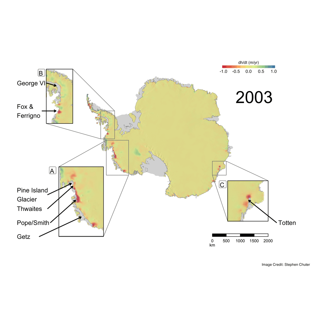
Fig. 1 – Annual rate of change in ice sheet height attributable to ice dynamics. Zoomed regions show (a) the Amundsen Sea Embayment and West Marie Byrd Land sectors of West Antarctica, (b) the Bellingshausen Sea Sector including the Fox and Ferrigno Ice Streams and glaciers draining into the George VI ice shelf and (c) the Totten Ice Shelf. The results are overlaid on a hill shade map of ice sheet elevation from Bedmap2 (Fretwell et al. 2013) and the grounding line and ice shelves are shown in grey (Depoorter et al. 2013). [Credit: Stephen Chuter]
Whilst we tend to think of the ice flow in Antarctica as a very slow and steady process, the wonders of satellites have shown over the last two decades it is one of the most dynamic places on Earth! This image of the week maps this dynamical change using all the satellite tools at a scientist’s disposal with novel statistical methods to work out why the change has recently been so rapid.
Why do we care about dynamic changes in Antarctica ?!
The West Antarctic Ice Sheet has the potential to contribute an approximate 3.3 m to global sea level rise (Bamber et al. 2009). Therefore, being able to accurately quantify observed ice sheet mass losses and gains is imperative for assessing not only their current contribution to the sea level budget, but also to inform ice sheet models to help better predict future ice sheet behaviour.
An ice sheet can gain or lose mass primarily through two different processes:
- changes in surface mass balance (variations in snowfall and surface melt driven by atmospheric processes) or
- ice dynamics, which is where variations in the flow of the ice sheet (such as an increase in its velocity) leads to changes in the amount of solid ice discharged from the continent into the ocean. In Antarctica ice flow dynamics are typically regulated by the ice shelves that surround the ice sheet; which provide a buttressing stress to help hold back the rate of flow.
Understanding the magnitude of each of these two components is key to understanding the external forcing driving the observed ice sheet changes.
This Image of the Week shows the annual rates of ice sheet elevation change which are attributed to changes in ice dynamics between 2003 and 2013 (Fig. 1) (Martín-Español et al. 2016). This is calculated by combining observations from multiple satellites (GRACE, ENVISAT, ICESat and CryoSat-2) with in-situ GPS measurements in a Bayesian Hierarchical Model. The challenge we face is that the observations we have of ice sheet change (whether that being total height change from altimetry or mass changes from GRACE) vary on their spatial and temporal scales and can only tell us the total mass change signal, not the magnitudes or proportions of the underlying processes driving it. The Bayesian statistical approach used here takes these observations and separates them proportionally into their most likely processes, aided by prior knowledge of the spatial and temporal characteristics for each process we want to resolve. This allows us reducing the reliance on using forward model outputs to resolve for processes we cannot observe. As a result, it is unique from other methods of determining ice sheet mass change, which rely on model outputs which in some cases have hard to quantify uncertainties. This methodology has been applied to Antarctica and is currently being used to resolve the sea level budget and its constituent components through the ERC GlobalMass project.
What can we learn from Bayesian statistical approach?
This approach firstly allows us to quantitively assess the annual contribution that the Antarctic ice sheet is making to the global sea level budget, which is vital to better understanding the magnitude each Earth system process is playing in sea level change. Additionally, by being able to break down the total change into its component processes, we can better understand what external factors are driving this change. Ice dynamics has been the dominant component of mass loss in recent years over the West Antarctic Ice Sheet and is therefore the process being focussed on in this image.
Amundsen Sea Embayment : a rapidly thinning area
Since 2003 there have been major changes in the dynamic behaviour over the Amundsen Sea Embayment and West Marie Byrd Land region (Fig 1, inset a). This region is undergoing some of the most rapid dynamical changes across Antarctica, with a 5 m/yr ice dynamical thinning near the outlet of the Pope and Smith Glacier. Additionally the Bayesian hierarchical model results show that dynamic thinning has spread inland from the margins of Pine Island Glacier, agreeing with elevation trends measured by satellite altimetry over the last two decades (Konrad et al. 2016).
These changes are driven primarily by the rapid thinning of the floating ice shelves at the ice sheet margin in this region
The importance of ice dynamics is also illustrated in Fig 2, which shows surface processes and ice dynamics components of mass changes over the Amundsen Sea Embayment from the bayesian hierarchical model. Fig 2 demonstrates that ice dynamics is the primary driver of mass losses in the region. Ice dynamic mass loss increased dramatically from 2003-2011, potentially stabilising to a new steady state since 2011.

Fig. 2 – Annual mass changes due to ice dynamics (pink line) and SMB (blue line) for the period 2003-2013 from the Bayesian hierarchical model approach. Red dots represent mass change anomaly (changes from the long term mean) due to surface mass balance calculated by the RACMO2.3 model and allow for comparison with our Bayesian framework results. (calculated from observations of ice velocity and ice thickness at the grounding line and allow for comparison with our Bayesian framework results (Mouginot et al, 2014). [Credit: Fig. 9b from Martín-Español et al., 2016].
The onset of dynamic thinning can also be seen in glaciers draining into the Getz Ice Shelf, which is experiencing high localised rates of ice shelf thinning up to 66.5 m per decade (Paolo et al. 2015) . This corroborates with ice speed-up recently seen in the region (Chuter et al. 2017; Gardner et al. 2018). We have limited field observations of ice characteristics in this region and therefore more extensive surveys are required to fully understand causes of this dynamic response.
Bellingshausen Sea Sector : Not as stable as previously thought…
The Bellingshausen Sea Sector (Fig 1, inset b) was previously considered relatively a dynamically stable section of the Antarctic coastline, however recent analysis from a forty year record of satellite imagery has shown that the majority of the grounding line in this region has retreated (Christie et al. 2016). This is reflected in the presence of a dynamic thinning signal in the bayesian hierarchical model results near the Fox and Ferrigno Ice streams and over some glaciers draining into the George VI ice shelf, which have been observed from CryoSat-2 radar altimetry (Wouters et al. 2015). The dynamic changes in this region over the last decade highlight the importance of continually monitoring all regions of the ice sheet with satellite remote sensing in order to understand the what the long term response over multiple decades is to changes in the Earth’s climate and ocean forcing.
Outlook
Multiple satellite missions have allowed us to measure changes occurring across the ice sheet in unprecedented detail over the last decade. The launch of the GRACE-Follow On mission earlier this week and the expected launch of ICESat-2 in September will ensure this capability continues well into the future. This will provide much needed further observations to allow us to understand ice sheet dynamics over time scales of multiple decades. The bayesian hierarchical approach being demonstrated will be developed further to encompass these new data sets and extend the results into the next decade. In addition to satellite measurements, the launch of the International Thwaites Glacier Collaboration between NERC and NSF will provide much needed field observations for the Thwaites Glacier region of the Amundsen Sea Embayment, to better understand whether it has entered a state of irreversible instability .
Data
The Bayesian hierarchical model mass trends shown here (Martín-Español et al. 2016) are available from the UK Polar Data Centre. In addition, the time series has been extended until 2015 and is available on request from Stephen Chuter (s.chuter@bristol.ac.uk). This work is part of the ongoing ERC GlobalMass project, which aims to attribute global sea level rise into its constituent components using a Bayesian Hierarchical Model approach. The GlobalMass project has received funding from the European Union’s Horizon 2020 research and innovation programme under grant agreement No 69418.
References
Christie, Frazer D. W. et al. 2016. “Four-Decade Record of Pervasive Grounding Line Retreat along the Bellingshausen Margin of West Antarctica.” Geophysical Research Letters 43(11): 5741–49. http://doi.wiley.com/10.1002/2016GL068972.
Chuter, S.J., A. Martín-Español, B. Wouters, and J.L. Bamber. 2017. “Mass Balance Reassessment of Glaciers Draining into the Abbot and Getz Ice Shelves of West Antarctica.” Geophysical Research Letters 44(14).
Gardner, Alex S. et al. 2018. “Increased West Antarctic and Unchanged East Antarctic Ice Discharge over the Last 7 Years.” Cryosphere 12(2): 521–47.
Martín-Español, Alba et al. 2016. “Spatial and Temporal Antarctic Ice Sheet Mass Trends, Glacio-Isostatic Adjustment, and Surface Processes from a Joint Inversion of Satellite Altimeter, Gravity, and GPS Data.” Journal of Geophysical Research: Earth Surface 121(2): 182–200. http://dx.doi.org/10.1002/2015JF003550.
Mouginot, J, E Rignot, and B Scheuchl. 2014. “Sustained Increase in Ice Discharge from the Amundsen Sea Embayment, West Antarctica, from 1973 to 2013.” Geophysical Research Letters 41(5): 1576–84.
Paolo, Fernando S, Helen A Fricker, and Laurie Padman. 2015. “Volume Loss from Antarctic Ice Shelves Is Accelerating.” Science 348(6232): 327–31. http://www.sciencemag.org/content/early/2015/03/31/science.aaa0940.abstract.
Edited by Violaine Coulon and Sophie Berger
 Stephen Chuter is a post-doctoral research associate in Polar Remote Sensing and Sea Level at the University of Bristol. He combines multiple satellite and ground observations of ice sheet and glacier change with novel statistical modelling techniques to better determine their contribution to the global sea level budget. He tweets as @StephenChuter and can be found at www.stephenchuter.wordpress.com. Contact email: s.chuter@bristol.ac.uk