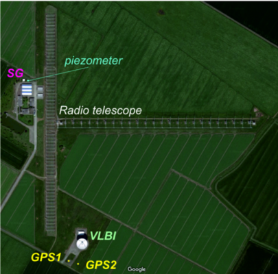
View of the Medicina observatory.
The site hosts a superconducting gravimeter (SG) installed in a dedicated building next to a piezometer. Local height variations are monitored by means of two GPS stations, located at the end of the N-S segment of the “North Cross” radio telescope. The two GPS stations are about 30 m apart and are close to a VLBI antenna.
Geodetic observations have proven to provide a fundamental base for advances in Earth-system sciences, while simultaneously supporting critical societal applications such as navigation, land planning and disaster management.
However, the interpretation of geodetic records is far from being a trivial task. The available observables typically respond to multiple geophysical phenomena; in turn, these phenomena can span over various temporal and spatial scales and can involve mass transfer and energy fluxes between the different parts of the system Earth. Therefore, one of the most exciting challenges that geodesy is currently facing concerns recognizing the fingerprints of different geophysical processes in the available observations.
In our recent talk at the EGU General Assembly, we focused on results derived from 20 years of continuous height and gravity measurements acquired at Medicina, Italy. Gravity data are well-suited to illustrate the complex interplay between different processes because they embed the effects of both mass variations and crustal deformation. Our study aimed to characterize the different contributions to the gravity data and quantitatively assess the agreement between independent observing techniques.
Thanks to the wealth of data collected during all these years, we were able to conclude that the gravity behavior in Medicina is mostly governed by the natural land subsidence and by regional non-linear variations in terrestrial water storage. For the first time, we have managed to quantify the temporal variations of geo-technical phenomena controlling the soil response to variations in surface fluids. As these phenomena can induce damages to the walls of buildings such as, for example, residential structures, any improvement in their understanding has also a valuable societal impact. By carefully modeling all the relevant components, we were able to reproduce gravity data with an overall agreement in the order 10 nm/s^2.
The long-term and effective collaboration between the Department of Physics and Astronomy of the University of Bologna and the German Federal Agency for Cartography and Geodesy made this experiment possible. There have been many challenges to overcome during the journey, but the insights revealed after (the first!) twenty years of operation tell us about a successful geodetic story.
Edited by Katrin Bentel
Author:
 Sara Bruni is the recipient of the Geodesy Division Outstanding Early Career Scientist Award 2018 and a post-doc researcher at the Department of Physics and Astronomy of the University of Bologna, Italy. Her research interests include the combination of space geodetic techniques for the realization of the ITRF, sea-level studies in the Mediterranean area and the separation of signals in gravity dataset. You can contact her at sara.bruni4@unibo.it.