
Dr. Francesca Funiciello
Francesca Funiciello is an Associated Professor at Roma Tre University (Rome, Italy). Her research interests are, among others, geodynamics, seismotectonics, rheology of analogue materials and science communication. She leads an active and young research group composed by Fabio Corbi, Silvia Brizzi and Elenora van Rijsingen, and collaborates with many other young and experienced researchers in Europe. The main activities of Francesca, Fabio, Silvia and Elenora involve analogue and numerical modelling of subduction zones, geophysical data analysis and geostatistics in the field of mega-earthquakes.
- Hi guys, can you tell us a bit more about “mega-earthquakes” and why it is so important to study them?
The interface between the subducting and overriding plates (Fig.1), the so-called megathrust, hosts the largest earthquakes on our planet Earth. They are generally called mega-earthquakes, with the prefix ‘mega’ highlighting both the fault originating them and their size. A quite recent example of a mega-earthquake is the Sumatra-Andaman event that occurred in 2004. The length of the fault that ruptured was ca. 1000 km and it generated a magnitude in the range of Mw 9.1–9.3 (Lay et al., 2005; Stein & Okal 2005; Subarya et al., 2006; Fujii & Satake 2007), where Mw denotes moment magnitude, a logarithmic measure of earthquake size. There had not been an event so large since the 1964 Alaska earthquake. The energy released during the Sumatra-Andaman 2004 event was in the range 5–10×1022 Nm—equivalent to the sum of the moment of all earthquakes in the preceding decade, worldwide (Lay et al., 2005).
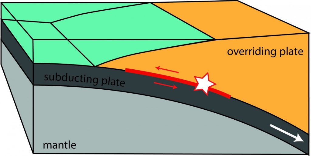
Figure 1 – Schematic section through a subduction zone. The interface between the overriding and subducting plate is the so-called megathrust. The red star highlights the hypocenter of a megathrust earthquake (courtesy of S. Brizzi).
Subduction mega-earthquakes (together with the tsunamis they may generate) are among the largest hazards for human life, considering that millions of people live in proximity of subduction zones (e.g., the NE-Japanese and South American subduction zones), which are located at the edges of the Pacific Ocean.
- Which approach does the scientific community adopt to study mega-earthquakes?
There is a large international effort for studying mega-earthquakes, using a wide spectrum of geo-disciplines to tackle various problems related to mega-earthquakes. Among others, they include seismology, geodesy, and modelling. While seismology and geodesy deal with real earthquakes, modelling allows reproducing the basic physics of the natural phenomena in the laboratory or with computer codes. Since mega-earthquakes are the result of multiple-interrelated processes, usually the best studies use a multidisciplinary approach.
- And you, which projects are you currently involved in?
We have been and are currently involved in several projects that aim to unravel the behaviour of the subduction process and the seismicity occurring along the megathrust. One of these projects was called: ‘Convergent margins and seismogenesis: defining the risk of great earthquakes by using statistical analysis and modelling’. Its aim was to improve the current understanding of the physics governing subduction megathrust earthquakes and to highlight the ingredients likely responsible for the diversity of interplate seismicity. The project, hosted at the Laboratory of Experimental Tectonics (LET) of Roma Tre University in Italy, was supported by the European Science Foundation (EURYI). The LET team has also been involved in many other projects, including several ITN projects, such as ‘Crystal to Plate’, ‘TOMOMOD’, ‘CREEP”’ and ‘SUBITOP’ and the Marie Curie project ‘ASPSYNC’, which all supported our scientific interests.
- What are the main difficulties of your research and which perspectives can we expect from the study of mega-earthquakes?
An intrinsic limitation of the study of earthquakes is the short amount of observations with respect to the multi-century recurrence time of mega-earthquakes. The instrumental seismic record is only available from the beginning of the last century while the geodetic one spans a few decades or less. Moreover, despite the recent technical improvements, it is still difficult to univocally constrain a single event. Just think about the variability between slip inversions obtained by different research groups for a given earthquake.
Slip inversion is a widely used method that determines the spatial distribution of the slip along the fault plane using data recorded at the surface. When an earthquake occurs, researchers use different kind of data (e.g., seismic waves, GPS data) to perform a slip inversion and usually, the slip models for the same event portray some discrepancies, in particular regarding the intensity of slip and its distribution, in particular in the shallow portion of the megathrust.
It is challenging to think about all the possible scientific advancements that can shed light on this peculiar natural process, the largest hazard for human life. And for this purpose, the keyword is ‘multidisciplinarity’. Hence, we aim to adopt a combination of methodologies, which help us to approach the seismically active portion of the convergent plate boundary, not as an isolated structure, but as part of a complex dynamic system, characterized by interrelated processes operating over a wide range of spatial and temporal scales. Only such an approach can highlight how the long-term dynamics of convergent margins play out in short-term seismogenic processes. In this multidisciplinary approach, models play an important role. Why models? As said, the instrumental seismic record is very short and the historical and geological archives lack of resolution and completeness. Furthermore, the absence of direct observations related to the relatively unknown and complex subduction megathrusts makes modelling a fundamental tool to study interplate subduction earthquakes.
References
Fujii, Y., Satake, K., 2007. Tsunami source of the 2004 Sumatra-Andaman earthquake inferred from tide gauge and satellite data. Bull. Seismol. Soc. Am. 97, S192–S207. doi:10.1785/0120050613
Lay, T., Kanamori, H., Ammon, C.J., Nettles, M., Ward, S.N., Aster, R.C., Beck, S.L., Bilek, S.L., Brudzinski, M.R., Butler, R., DeShon, H.R., Ekstrom, G., Satake, K., Sipkin, S., 2005. The Great Sumatra-Andaman Earthquake of 26 December 2004. Science 308, 1127–1132. doi:10.1126/science.1112250
Stein, S., Okal, E.A., 2005. Speed and size of the Sumatra earthquake. Nature 434, 581–582. doi:doi:10.1038/434581a
Subarya, C., Chlieh, M., Prawirodirdjo, L., Avouac, J.-P., Bock, Y., Sieh, K., Meltzner, A.J., Natawidjaja, D.H., McCaffrey, R., 2006. Plate-boundary deformation associated with the great Sumatra-Andaman earthquake. Nature 440, 46–51. doi:10.1038/nature04522