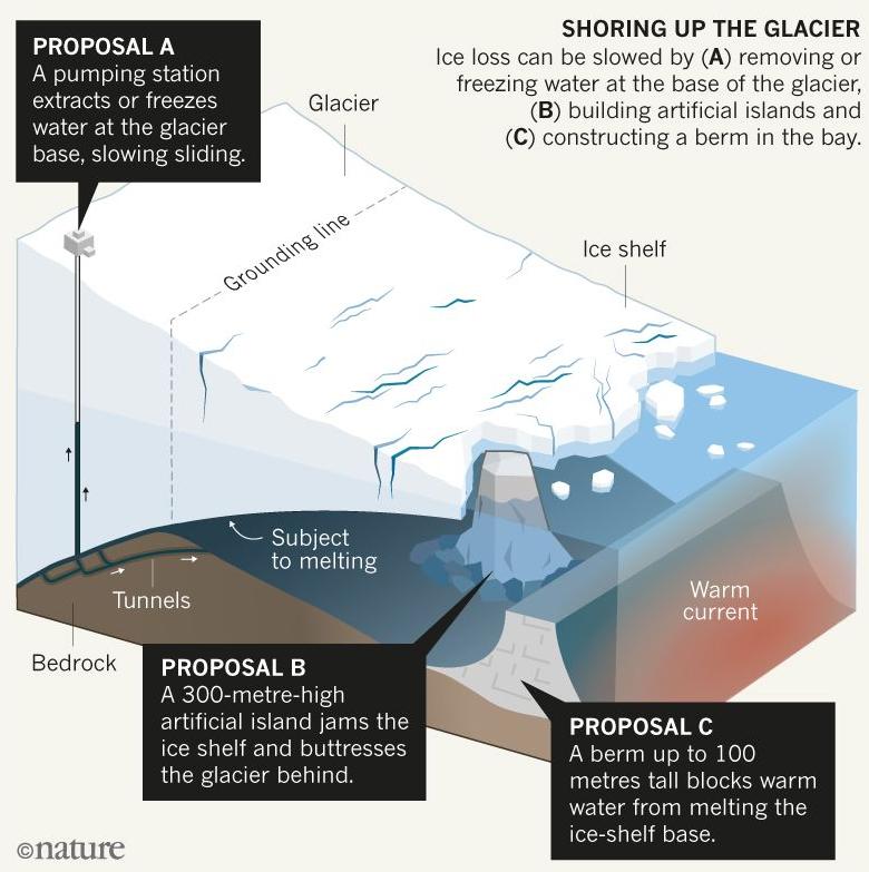
Figure 1: Three examples of glacial geoengineering techniques to mitigate sea-level rise from ice-sheet melting [Credit: Adapted from Figure 1 of Moore et al. (2018); Design: Claire Welsh/Nature].
As the climate is currently warming, many countries and cities are preparing to cope with one of its major impacts, namely sea-level rise. Up to now, the mitigation of climate change has mainly focused on the reduction of greenhouse gas emissions. Large-scale geoengineering has also been proposed to remove carbon from the atmosphere or inject aerosols into the stratosphere to limit the rise in temperature. But locally-targeted geoengineering techniques could also provide a way to avoid some of the worst impacts, like the sea-level rise. In this Image of the Week, we present examples of such a technique that could be applied to the Antarctic and Greenland ice sheets (Moore et al., 2018; Wolovick and Moore, 2018).
Sea level is rising…
The sea level of the world oceans has been rising at a mean rate of 3 mm per year since the 1990s, mainly due to ocean thermal expansion, land-ice melting and changes in freshwater storage (see this post). More than 90% of coastal areas could experience a sea-level rise exceeding 20 cm with a 2°C warming (relative to the pre-industrial period), which is likely to happen by the middle of this century (Jevrejeva et al., 2016).
The Antarctic and Greenland ice sheets constitute two huge reservoirs of ice and contain the equivalent of 60 and 7 m of sea-level rise, respectively, if completely melted. Although a complete disintegration of these two ice sheets is not on the agenda in the coming years, surface melting of the Greenland ice sheet and the flow of some major polar glaciers could be enhanced by different positive feedbacks (see this post on climate feedbacks and this post on marine ice sheet instability). These feedbacks would elevate the sea level even more than projected by the models.
… but could potentially be delayed by glacial geoengineering
In order to cope with this threat, reducing our greenhouse gas emissions might not be sufficient to delay the rise of sea level. One alternative has been suggested by Moore et al. (2018) and consists of using glacial geoengineering techniques in the vicinity of fast-flowing glaciers of the Antarctic and Greenland ice sheets. They propose three different ways to delay sea-level rise from these glaciers and these are presented in our Image of the Week (Fig. 1):
A. A pumping station could be installed at the top of the glacier with the aim of extracting or freezing the water at the glacier base. This would slow down the glacier sliding on the bedrock and reduce its contribution to sea-level rise.
B. An artificial island (about 300 m high) could be built in the cavity under the floating section of the glacier (or ice shelf). This would enhance the so-called buttressing effect (see this post) and decrease the glacier flow to the ocean.
C. A wall of up to 100 m high could be built in the ocean bay right in the front of the ice shelf. This would block (partially or completely) any warm water circulating underneath the ice shelf and delay the sub-shelf melting (see this post).
In theory
Wolovick and Moore (2018) studied in detail the possibility of building artificial islands (proposal B above) underneath the ice shelf of Thwaites Glacier (West Antarctica), one of the largest glacier contributors to the ongoing sea-level rise. They used a simple ice-flow model coupled to a simple ocean model and considered different warming scenarios in which they introduced an artificial island underneath the ice shelf.
Figure 2 below illustrates an example coming from their analysis. In the beginning (Fig. 2b), the grounding line (separation between the grounded ice sheet in blue and the floating ice shelf in purple) is located on top of a small mountain range. When running the model under a global warming scenario, the grounding line retreats inland and the glacier enters into a ‘collapsing phase’ (Fig. 2c; marine ice sheet instability). The introduction of an artificial island under the ice shelf with a potential to block half the warm ocean water allows the ice shelf to reground (Fig. 2d; the ice-shelf base touches the top of the small island below). The unprotected seaward part of the ice shelf shrinks over time, while the protected inland part thickens and regrounds (Fig. 2e-f), which overall decreases the glacier mass loss to the ocean.
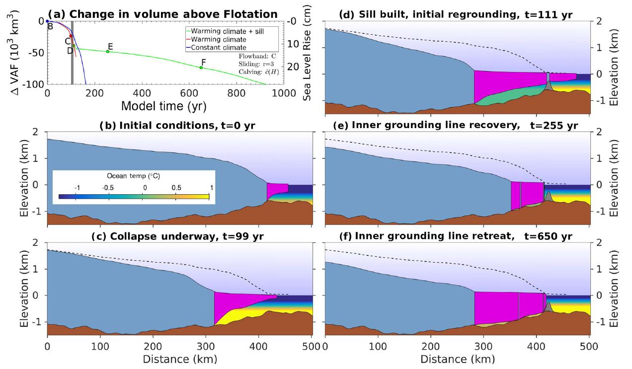
Figure 2: Example of a model experiment realized on Thwaites Glacier by Wolovick and Moore (2018). Different times are presented and show the (b) initial state, (c) the collapse underway, (d) the initial effect of the construction of the artificial island below the ice shelf, (e) the removal of the seaward ice shelf and thickening of the landward ice shelf, (f) the stabilization of the glacier [Credit: Figure 5 of Wolovick and Moore (2018)].
In practice
The model experiments presented above show that delaying sea-level rise from glacier outflow is possible in theory. In practice, this would mean substantial geoengineering efforts. For building a small artificial island under the ice shelf of Pine Island Glacier (West Antarctica), 0.1 km3 of gravel and sand would be necessary. That same quantity would be sufficient to build a 100 m high wall in front of Jakobshavn Glacier (Greenland) to prevent warm water from melting the ice base. For building such a wall in front of Pine Island Glacier, a quantity of 6 km3 (60 times more than Jakobshavn) of material would be needed.
In comparison, the Three Gorges Dam used 0.03 km3 of cast concrete, the Hong Kong’s airport required around 0.3 km3 of landfill, and the excavation of the Suez Canal necessitated 1 km3 of material. Thus, the quantities needed for building glacial geoengineering structures are comparable in size to the current large engineering projects.
However, many other aspects need to be considered when implementing such a project. In particular, the construction of such structures in cold waters surrounded by icebergs and sea ice is much more difficult than in a typical temperate climate. A detailed study of physical processes in the region of the glacier, such as ocean circulation, iceberg calving, glacier sliding and erosion, and melting rates, is needed before performing such projects. Also, the number of people needed to work on a project of this scale is an important factor to include.
Potential adverse effects
Beside all the factors that need to be considered to implement such a project, there is a list of potential adverse effects. One of the main risks is to the marine ecosystems, which could be affected by the constructions of the islands and walls. Also, if not properly designed, the geoengineering solutions could accelerate the sea-level rise instead of delaying it. For instance, in the case of water extraction (proposal A above), the glacier might speed up rather than slow down if water at the glacier’s base is trapped in pockets.
Wolovick and Moore (2018) do not advocate that glacial geoengineering is done any time soon, due to the different factors mentioned above. Instead, they suggest that we start thinking about technological solutions that could delay sea-level rise. Other studies also look at different glacial geoengineering ideas (see this post).
In summary
Glacial geoengineering techniques constitute a potential way to cope with one of the greatest challenges related to global warming, namely sea-level rise. In theory, these projects are possible, while in practice a series of technical difficulties and potential ecological risks do not allow us to implement them soon.
While important to keep thinking about these solutions, the most important action that humanity can take in order to delay sea-level rise is to mitigate greenhouse gas emissions. And scientists like us need to keep carefully studying the cryosphere and the Earth’s climate in general.
Further reading
-
-
- Moore, J. C., R. Gladstone, T. Zwinger, M. Wolovick (2018). Geoengineer polar glaciers to slow sea-level rise. Nature, 555: 303-305, 10.1038/d41586-018-03036-4.
- Wolovick, M., J. C. Moore (2018). Stopping the flood: could we use targeted geoengineering to mitigate sea level rise? The Cryosphere, 12: 2955-2967, doi: 10.5194/tc-12-2955-2018.
-
Ice-hot news: The cryosphere and the 1.5°C target
-
Edited by Jenny Turton
David Docquier is a post-doctoral researcher at the Earth and Life Institute of Université catholique de Louvain (UCL) in Belgium. He works on the development of processed-based sea-ice metrics in order to improve the evaluation of global climate models (GCMs). His study is embedded within the EU Horizon 2020 PRIMAVERA project, which aims at developing a new generation of high-resolution GCMs to better represent the climate.