Geotalk is a regular feature highlighting early career researchers and their work. In this interview we speak to Matthias Vanmaercke, an associate professor at the University of Liège in Belgium who studies soil erosion and land degradation across Europe and Africa. At the EGU General Assembly he received the 2018 Soil System Sciences Division Outstanding Early Career Scientists Award.
Thanks for talking to us today! Could you introduce yourself and tell us about your career path so far?
Hi! So I am Matthias Vanmaercke. I’m from Belgium. I’m studied physical geography at the University of Leuven in Belgium, where I also completed my PhD, which focused on the spatial patterns of soil erosion and sediment yield in Europe. After my PhD, I continued working on these topics but with a stronger emphasis on Africa. Since November 2016, I became an associate professor at the University of Liege, Department of Geography where I continue this line of research and teach several courses in geography.
At the 2018 General Assembly, you received a Division Outstanding Early Career Scientists Award for your contributions towards understanding soil erosion and catchment sediment export (or the amount of eroded soil material that gets effectively transported by a river system).
Could you give us a quick explanation of these processes and how they impact our environment and communities?
We have known for a long time that soil erosion and catchment sediment export pose important challenges to societies. In general, our soils provide many important ecosystem services, including food production via agriculture. However, in many cases, soil erosion threatens the long term sustainabilty of these services.
Several erosion processes, such as gully erosion, often have more direct impacts as well. These include damage to infrastructure and increased problems with flooding. Gullies can also greatly contribute to the sediment loads of rivers by directly providing sediments and also by increasing the connectivity between eroding hill slopes and the river network. These high sediment loads are in fact the off-site impacts of soil erosion and often cause problems as well, including deteriorated water quality and the sedimentation of reservoirs (contributing to lower freshwater availability in many regions).

Matthias Vanmaercke, recipient of the 2018 Soil System Sciences Division Outstanding Early Career Scientists Award. Credti: Matthias Vanmaercke.
What recent advances have we made in predicting these kinds of processes?
Given that we live in an increasingly globalised and rapidly changing world, there is a great need for models and tools that can predict soil erosion and sediment export as our land use and climate changes.
However, currently our ability to predict these processes, foresee their impacts and develop catchment management and land use strategies remains limited. This is particularly so at regional and continental scales and especially in Africa. For some time, we have been able to simulate processes like sheet and rill erosion fairly well. However, other processes like gully erosion, landsliding and riverbank erosion, remain much more difficult to simulate.
Nonetheless, the situation is clearly improving. For example, with respect to gully erosion, we already know the key factors and mechanisms that drive this process. The rise of new datasets and techniques helps to translate these insights into models that will likely be able to simulate these processes reasonably well. I expect that this will become feasible during the coming years.
What is the benefit of being able to predict these processes? What can communities do with this information?
These kinds of predictions are relevant in many ways. Overall, soil erosion is strongly driven by our land use. However, some areas are much more sensitive than others (e.g. steep slopes, very erodible soil types). Moreover, many of these different erosion processes can interact with each other. For example, in some cases gully formation can entrain landslides and vice versa.
Models that are capable of predicting these different erosion processes and interactions can strongly help us in avoiding erosion, as they provide information that is useful for planning our land use better. For instance, these models can help determine which areas are best reforested or where soil and water conservation measures are needed.
They also help with avoiding and mitigating the impacts of erosion. Many of these processes are important natural hazards (e.g. landsliding) or are strongly linked to them (e.g. floods). Models that can better predict these hazards contribute to the preparedness and resilience of societies. This is especially relevant in the light of climate change.
However, there are also impacts on the long-term. For example, many reservoirs that were constructed for irrigation, hydropower production or other purposes fill up quickly because eroded sediments that are transported by the river become deposited behind the dam. Sediment export models are essential for predicting at what rate these reservoirs may lose capacity and for designing them in the most appropriate ways.
At the Assembly you also gave a presentation on the Prevention and Mitigation of Urban Gullies Project (PREMITURG-project). Could you tell us a bit more about this initiative and its importance?
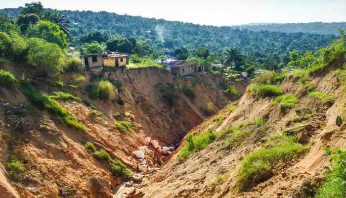
Urban mega-gullies are a growing concern in many tropical cities of the Global South. These urban gullies are typically several metres wide and deep and can reach lengths of more than one kilometre. They typically arise from a combination of intense rainfall, erosion-prone conditions, inappropriate city infrastructure and lack of urban planning and are often formed in a matter of hours due to the concentration of rainfall runoff.
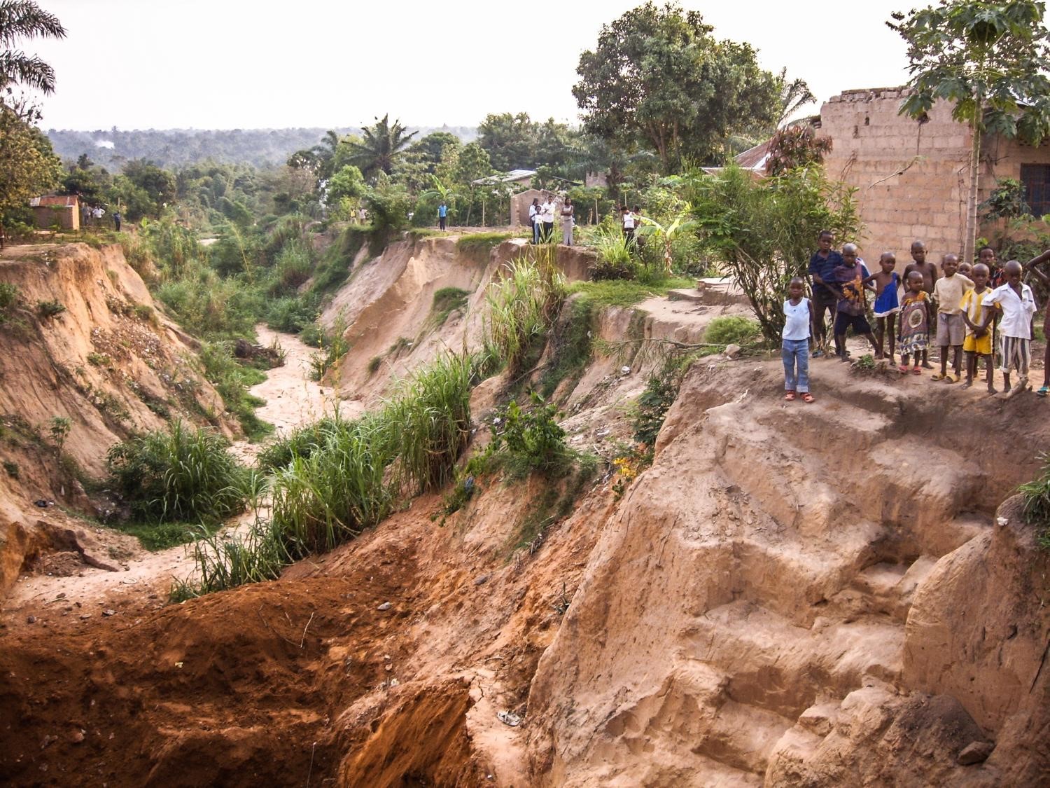
Urban gully in Mbuji-Maji, Democratic Republic of Congo, September 2008. Credit: Matthias Vanmaercke
Given their nature and location in densely populated areas, they often claim casualties, cause large damage to houses and infrastructure, and impede the development of many (peri-)urban areas. These problems directly affect the livelihood of likely millions of people in several countries, such as the Democratic Republic of Congo, Nigeria, and Angola. Due to the rapid growth of many cities in these countries and, potentially, more intensive rainfall, this problem is likely to aggravate in the following decades.
With the ARES-PRD project PREMITURG, we aim to contribute to the prevention and mitigation of urban gullies by better studying this problem. In close collaboration with the University of Kinshasa in the Democratic Republic of Congo (DRC) and several other partners and institutes, we will study this underestimated geomorphic hazard across several cities in DRC. With this, we hope to provide tools that can predict which areas are the most susceptible to urban gullying so that this can be taken into account in urban planning efforts. Likewise, we hope to come up with useful recommendations on which techniques to use in order to prevent or stabilise these gullies. Finally, we also aim to better understand the societal and governance context of urban gullies, as this is crucial for their effective prevention and mitigation.
Interview by Olivia Trani, EGU Communications Officer
Fatoba Olanrewaju
Great suggestion. I was wandering and looking at the houses at the edge of the steep slope. That’s very dangerous to the lives of those who live in such areas. As a civil engineer, I think there are easy solutions that could help safeguard the lives of people living on such areas.
Mikhail Butusov
Sorry for my not very postitive comment on the article about prevention of slopes erosion.
The main author’s suggestion is that “scientists should provide tools that can predict which areas are the most susceptible to urban gullying, etc…and hope to come up with useful recommendations on which techniques to use etc….” The question remains “who and how those, who are not sitting in their labs, but live at the edge of the steep slope, should guard their lives and those of their families?” In the meantime, there are dozen of technologies to fight with erosion. To find them, one does not need to wait till the end of ARES-PRD project. This type of science remains miles off from the real hazard.