Inspired by a post on Lifehacker on what your average geologist carries in their rucksack/backpack, we’ve put together a few blog posts showcasing what a range of our EGU members carry in their bags whilst in the field!
Of course, fieldwork in Northern Europe vs. research in Australia is very different, think only of the weather! The same is true if you’ve been embarked on research in the Arctic vs. the Amazon, for instance.
The first bag we take a peek into belongs to Zoe Mildon, a PhD researcher at University College London who has been carrying out research in the Italian Appennines. We’ve spoken to her about the items in her bag and why they are key to successful field work.
This bag belongs to: Zoe Mildon
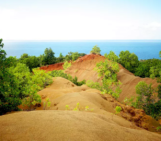
Field Work location: The central Apennines in the Abruzzo and Umbria regions of Italy
Duration of field work: Typically 1-3 weeks at a time, 3 months of fieldwork completed over course of PhD so far
Items in the bag:
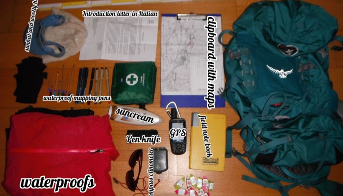
Foldable metre ruler, sunhat and woolly hat, letter in Italian explaining who I am and what I doing, clipboard with maps, fingerless gloves (able to write while wearing them!), colouring pencils, waterproof mapping pens, persona first aid kit, suncream, GPS, field note book, penknife (very important for lunch!), sunglasses, compass clinometer, sweets, waterproofs, camera (not shown, as it was used to take the picture)
What was the aim of the research?: I construct detailed structural maps of exposed bedrock normal fault scarps in the Italian Apennines, looking at variations in strike, dip, kinematics and

Zoe in the field. (Credit: Zoe Mildon)
geomorphology along strike of these faults. The ruler is used to construct a topographic profile across the fault scarps to calculate the throw rate (averaged over the Holocene). The maps that I have produced show that the exposed scarps have variable geometry and throw over a range of scales (m’s to km’s scale). This data is then used for a range of applications, including showing that slip propagated to the surface during and earthquake and modelling faults with variable 3D geometry (rather than modelling as a straight line).
The one item I couldn’t live without: my field note book. It has all my observations, discussions in the field and data within it. I’ve dropped it down a very steep hill and left it in an Italian’s car, both times I was very worried that I could have lost it forever. Luckily I managed to get it back both times. My penknife is also pretty important, how else will I cut up my focaccia and mozzarella for lunch?
If you’ve been on field work recently and would like the contents of your bag to feature on the blog, we’d love to hear from you. Please contact the EGU’s Communication Officer, Laura Roberts (networking@egu.eu)