During ice ages landscapes are sculpted by the power of advancing glaciers. From rock scratches, to changing mountains and the formation of corries, cirques and aretes, through to the formation of valleys and fjords, the effects of past glaciations are evident across the northern hemisphere landscape.
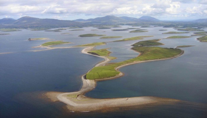
Perhaps not so familiar, drumlin fields are also vestiges of the erosive power of ancient ice sheets. Glacial deposits tend to be angular and poorly sorted, meaning they come in lots of different sizes and shapes. The extreme of this are glacial erratics. Drumlins are are elongated hills made up of glacial deposits and they represent bedforms produced below rapidly moving ice. Our Imaggeo on Monday’s image this week is of Clew Bay in western Ireland and shows the streamlining of drumlins into an extensive drumlin field of glacial sediment. The drumlins here formed during the rapid thinning of the fast moving central parts of the western sector of the British-Irish Ice Sheet, in a process known as deglacial downdraw – probably between 18,000 and 16,000 years ago. The ice was streaming through bays in western Ireland both during and at the end of the Last Glacial Maximum (also known as LGM). This was the time in which the ice sheets covered most of northern America, Europe and Asia. In Clew Bay the ice was a minimum of 800m thick and flowing out into a series of tidewater glaciers situated along the length of Ireland’s western shelf.
By Prof. Peter Coxon, Head of Geography, School of Natural Sciences, Trinity College Dublin & Laura Roberts
Imaggeo is the EGU’s online open access geosciences image repository. All geoscientists (and others) can submit their photographs and videos to this repository and, since it is open access, these images can be used for free by scientists for their presentations or publications, by educators and the general public, and some images can even be used freely for commercial purposes. Photographers also retain full rights of use, as Imaggeo images are licensed and distributed by the EGU under


Pingback: GeoLog | Imaggeo on Mondays: Concord at midnight