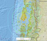
On Sunday the 13th November, New Zealand’s South Island was struck by a powerful 7.8 M earthquake. Initial analysis by the United States Geological Survey (USGS) indicates that the source of the tremor was faulting on or near the boundary between the Pacific and Australia plates. A tsunami alert (no longer active) was triggered following the earthquake, with risk of tsunami waves along coastal areas. The maximum wave high recorded by a gauge at Kaikoura, 181 km north of Christchurch, was 2.5m, according to Weatherwatch.co.nz.
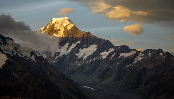
The collision of the two plates is also responsible for the formation of the Alpine Fault, which runs along the western flank of the Southern Alps, (Kā Tiritiri o te Moana). The mountain range runs 500km along the South Island, explains Katrina Sauer on our open access image repository, Imaggeo. In addition, the Alpine Fault is responsible for the uplift of this impressive mountain range. Sunkissed by a setting sun (pictured above), Aoraki/Mt. Cook is the highest mountain in New Zealand (3,724 m). Katrina took the beautiful picture from Mueller Hut.
For more information about yesterday’s earthquake, as well as photographs which depict the staggering aftermath of the tremors see the list of links below (by no means exhaustive):
- USGS Event pages – include a detailed and informative tectonic summary, as well as interactive maps, shake maps, moment tensor details and preliminary finite fault results.
- GeoNet (the official source of geological hazard information for New Zealand) provides an up-to-date list of recent earthquakes across the islands, as well as details about yesterday’s earthquake.
- What happened in New Zealand’s magnitude 7.5 earthquake? – an analysis by University of Melbourne academics for The Conversation.
- Explainer: How did New Zealand’s earthquake happen? Was it two quakes in one? (complete with video explaining oblique-reverse faults and liquefaction effects) by The Guardian.
- ‘Utter devastation’ after major quake, aftershocks hit New Zealand – detailed report by Reuters.
- New Zealand earthquake: Two dead following powerful tremor – BBC News
- New Zealand earthquake: thousands stranded and towns cut off – as it happened – live coverage by The Guardian.
For some of the latest news about the earthquake, you might also follow the #eqnz and #nzearthquake on Twitter. For details about New Zealand geology and why and how it’s tremors are triggered, you can follow Chris Rowan (@Allochthonous), Jascha Polet (@CPPGeophysics), @IRIS_EPO (particularly good for teaching resources for kids), and Anthony Lomax (@ALomaxNet) (among many other great scientists!).
Imaggeo is the EGU’s online open access geosciences image repository. All geoscientists (and others) can submit their photographs and videos to this repository and, since it is open access, these images can be used for free by scientists for their presentations or publications, by educators and the general public, and some images can even be used freely for commercial purposes. Photographers also retain full rights of use, as Imaggeo images are licensed and distributed by the EGU under a Creative Commons licence. Submit your photos at http://imaggeo.egu.eu/upload/.